|
ANTARCTICA
|
|||||||||||||||
|
HOME | BIOLOGY | FILMS | GEOGRAPHY | HISTORY | INDEX | INVESTORS | MUSIC | SOLAR BOATS | SPORT |
|||||||||||||||
|
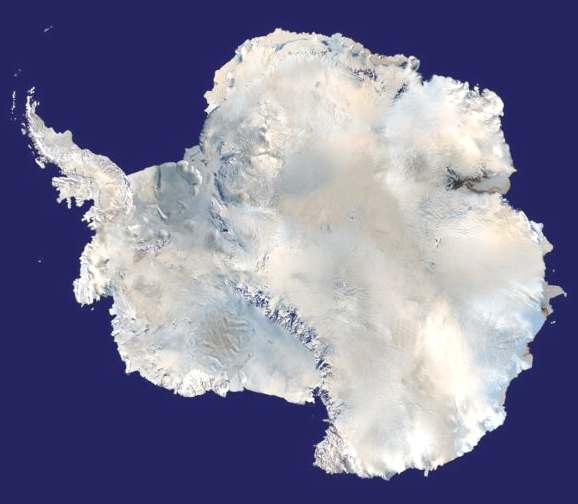
Antarctica is the southernmost continent and includes the South Pole. Geographic sources disagree as to whether it is surrounded by the Southern Ocean or the South Pacific Ocean, South Atlantic Ocean, and Indian Ocean. It is divided by the Transantarctic Mountains. On average, it is the coldest, driest, and windiest continent and has the highest average elevation of all the continents. At 14.425 million km², Antarctica is the third-smallest continent after Europe and Australia; 98% of it is covered in ice. Because there is little precipitation, except at the coasts, the interior of the continent is technically the largest desert in the world. There are no permanent human residents and Antarctica has never had an indigenous population. Only cold-adapted plants and animals survive there, including penguins, fur seals, mosses, lichens, and many types of algae. The name "Antarctica" comes from the Greek ανταρκτικός (antarktikos), meaning "opposite the Arctic."
Satellite composite image of Antarctica
Although myths and speculation about a Terra Australis ("Southern Land") date back to antiquity, the first confirmed sighting of the continent is commonly accepted to have occurred in 1820 by the Russian expedition of Mikhail Lazarev and Fabian Gottlieb von Bellingshausen. However, the continent remained largely neglected for the rest of the 19th century because of its hostile environment, lack of resources, and isolated location.
The Antarctic Treaty was signed in 1959 by 12 countries. The treaty prohibits military activities and mineral mining, supports scientific research, and protects the continent's ecozone. Ongoing experiments are conducted by more than 4,000 scientists of many nationalities and with different research interests.
History
Belief in the existence of a Terra Australis — a vast continent located in the far south of the globe to "balance" the northern lands of Europe, Asia and north Africa — had existed since Ptolemy suggested the idea in order to preserve symmetry of landmass in the world. Depictions of a large southern landmass were common in maps such as the early 16th century Turkish Piri Reis map. Even in the late 17th century, after explorers had found that South America and Australia were not part of "Antarctica," geographers believed that the continent was much larger than its actual size.
European maps continued to show this land until Captain James Cook's ships, HMS Resolution and Adventure, crossed the Antarctic Circle on January 17, 1773 and again in 1774. The first confirmed sighting of Antarctica can be narrowed down to the crews of ships captained by three individuals. According to various organizations (the National Science Foundation, NASA, the University of California, San Diego, and other sources), ships captained by three men sighted Antarctica in 1820: Fabian von Bellingshausen (a captain in the Russian Imperial Navy), Edward Bransfield (a captain in the British Navy), and Nathaniel Palmer (an American sealer out of Stonington, Connecticut). Von Bellingshausen supposedly saw Antarctica on January 27, 1820, three days before Bransfield sighted land, and ten months before Palmer did so in November 1820. On that day the two ship expedition led by Von Bellingshausen and Mikhail Petrovich Lazarev reached a point within 32 km (20 miles) of the Antarctic mainland and saw ice fields there.
In 1841, explorer James Clark Ross passed through what is now known as the Ross Sea and discovered Ross Island. He sailed along a huge wall of ice that was later named the Ross Ice Shelf. Mount Erebus and Mount Terror are named after two ships from his expedition: HMS Erebus and Terror.
During an expedition led by Ernest Shackleton in 1907, parties led by T. W. Edgeworth David became the first to climb Mount Erebus and to reach the South Magnetic Pole. In addition, Shackleton himself and three other members of his expedition made several firsts in December 1908 - February 1909: first humans to traverse the Ross Ice Shelf, the first humans to traverse the Transantarctic Mountain Range (via the Beardmore Glacier), and the first humans to set foot on the South Polar Plateau. On December 14, 1911, a party led by Norwegian polar explorer Roald Amundsen from the ship Fram became the first to reach the geographic South Pole, using a route from the Bay of Whales and up the Axel Heiberg Glacier.
Richard Evelyn Byrd led several voyages to the Antarctic by plane in the 1930s and 1940s. He is credited with implementing mechanized land transport and conducting extensive geological and biological research. However, it was not until October 31, 1956 that anyone set foot on the South Pole again; on that day a U.S. Navy group led by Rear Admiral George Dufek successfully landed an aircraft there.
Geography
Most of Antarctica is located south of the Antarctic Circle, surrounded by the Southern Ocean. It is the southernmost land mass and comprises more than 14 million km², making it the fifth-largest continent. The coastline measures 17 968 km (11,160 miles) and is mostly characterized by ice formations, as the following table shows:
Physically, it is divided in two by the Transantarctic Mountains close to the neck between the Ross Sea and the Weddell Sea. The portion west of the Weddell Sea and east of the Ross Sea is called Western Antarctica and the remainder Eastern Antarctica, because they roughly correspond to the Western and Eastern Hemispheres relative to the Greenwich meridian.
About 98% of Antarctica is covered by the Antarctic ice sheet. The ice sheet is, on average, 2.5 kilometers (1.6 miles) thick. The continent has approximately 90% of the world's fresh water, in the form of ice. In most of the interior of the continent precipitation is very low, down to 20 mm/yr; in a few "blue ice" areas precipitation is lower than mass loss by sublimation and so the local mass balance is negative. In the dry valleys the same effect occurs over a rock base, leading to a desiccated landscape.
Western Antarctica is covered by the West Antarctic Ice Sheet. The sheet has been of recent concern because of the real, if small, possibility of its collapse. If the sheet were to break down, ocean levels would rise by several meters in a relatively geologically short period of time, perhaps a matter of centuries. Several Antarctic ice streams, which account for about 10% of the ice sheet, flow to one of the many Antarctic ice shelves.
Vinson Massif, the highest peak in Antarctica at 4892 meters (16,050 feet), is located in the Ellsworth Mountains. Although Antarctica is home to many volcanoes, only Mt. Erebus is active. Mount Erebus, located in Ross Island, is the southernmost active volcano. There was another famous volcano called Deception Island, which is famous for its giant eruption in 1970. Minor eruptions are frequent and lava flow has been observed in recent years. Other dormant volcanoes may potentially be active. In 2004, an underwater volcano was found in the Antarctic Peninsula by American and Canadian researchers. Recent evidence shows this unnamed volcano may be active.
Antarctica is home to more than 70 lakes that lie thousands of meters under the surface of the continental ice sheet. Lake Vostok, discovered beneath Russia's Vostok Station in 1996, is the largest of these subglacial lakes. It is believed that the lake has been sealed off for 35 million years. There is some evidence that Vostok's waters may contain microbial life. The sealed, frozen surface of the lake shares similarities with Jupiter's moon Europa. Confirming that life can survive in Lake Vostok strengthens the argument for life on the satellite.
LINKS and REFERENCE
A taste for adventure capitalists
Solar Cola - a healthier alternative
|
|||||||||||||||
|
This
website
is Copyright © 1999 & 2006 NJK.
The bird |
|||||||||||||||
|
AUTOMOTIVE | BLUEBIRD | ELECTRIC CARS | ELECTRIC CYCLES | SOLAR CARS |