|
SALT LAKE CITY UTAH USA
|
|
|
HOME | INDEX | AUTOMOTIVE | BLUEPLANET | ELECTRIC CARS | E. CYCLES | NEWS | SOLAR CARS |
|
|
Salt Lake City is the state capital and most populous city in the U.S. state of Utah. The city's population, as of the 2000 Census, was 181,743. It is the seat of Salt Lake County, which encompasses the Salt Lake Valley and 15 other municipalities to include a total population of 978,285.
The Salt Lake City metropolitan area spans two additional counties, Summit and Tooele, and has a total estimated population of 1,005,232 in 2003. It is situated between two other metropolitan areas in an urbanized corridor called the Wasatch Front, which has a combined population of 2,009,595 as of 2005.
The city occupies the north end of the Salt Lake Valley at an elevation of 4,330 feet (1,320 m). The valley is surrounded by mountains that rise dramatically to an elevation of 11,752 feet (3,582 m). Named after the nearby Great Salt Lake - in fact, the original name was "Great Salt Lake City" - the city is separated from the lake's shore by marshes and mudflats. Residents are known as "Salt Lakers."
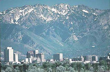
Salt Lake City skyline in the late 1980s with Wasatch Mountains pictured in background
Founded in 1847 by a group of Latter-day Saints (Mormons) led by Brigham Young, Salt Lake City is among the region's oldest cities and is the location of the headquarters of The Church of Jesus Christ of Latter-day Saints. Mining and railroads initially brought economic growth, and the city became known as the "Crossroads of the West." In the 21st Century the city has developed a strong tourism industry and was host to the 2002 Winter Olympics. It is also the business center of the rapidly growing Wasatch Front and the gateway to the heavily visited resort town of Park City.
History
Before Western settlement, the Shoshone, Ute, and Paiute had dwelled in the Salt Lake Valley for thousands of years. The first Caucasian Europeans to settle in the valley were the Latter-day Saints on July 24, 1847. They had traveled across the nation seeking an isolated area to practice their religion, away from the persecution they had faced in the East. Upon arrival their religious prophet Brigham Young reportedly stated, "This is the place."
Only four days after arriving in the Salt Lake Valley, Brigham Young designated the site for the Salt Lake Temple, the main temple for the Church of Jesus Christ of Latter-day Saints. Constructed on Temple Square, in the center of the city, the temple took 40 years to complete, being dedicated on April 6, 1893. It is the best-known structure in the city.
These Mormon Pioneers organized a new state called Deseret and petitioned its recognition in 1849. The United States Congress rebuffed the settlers in 1850 and established the Utah Territory. Great Salt Lake City replaced Fillmore as the territorial capital in 1858, and the name was subsequently abbreviated to Salt Lake City. The city's population swelled with an influx of religious converts, making it one of the most populous cities in the Old American West.
Disputes with the federal government ensued over widespread religious practice of polygamy. A climax occurred in 1857, with President James Buchanan declaring the area in rebellion when Brigham Young refused to step down as governor. The conflict called the Utah War began. A division of the United States Army marched through the city and found that it had been evacuated. This division set up Camp Floyd approximately 40 miles (65 km) southwest of the city. Another military installation, Fort Douglas, was established in 1862 to maintain Union allegiance during the American Civil War. Many area leaders were incarcerated at the territorial prison in Sugar House in the 1880s for violation of polygamy laws. The LDS Church conceded in 1890, releasing "The Manifesto," which officially renounced polygamy in the church. This paved the way for statehood in 1896, when Salt Lake City became the state capital.
The First Transcontinental Railroad was completed in 1869 at Promontory Summit on the north side of the Great Salt Lake. A railroad was connected to the city from the Transcontinental Railroad in 1870 making travel less burdensome. Mass migration of different groups followed. They found economic opportunities in the booming mining industries. These groups constructed the Greek Orthodox Holy Trinity Cathedral in 1905 and the Roman Catholic Cathedral of the Madeleine in 1909, the first major churches not of the Latter-day Saint faith. Both cathedrals are historic icons.
During the late 19th and early 20th centuries, an extensive streetcar system was constructed throughout the city. The first streetcar began service in 1872. Due to speed issues, electrification of the system began in 1889. However, due to the rising American interest in the automobile in the early 20th century, the last tram line was dismantled in 1945. Mass transit wasn't re-instigated until TRAX, a light rail system, opened in 1999.
Population growth began to stagnate during the 20th century with the advent of suburban life. High birth rates combined with migration from defunct mining towns led to explosive growth in its suburbs. As a result the suburban population greatly outnumbers the city proper itself. A major concern of recent government officials has been combating inner-city decay. The city lost population from the 1960s through the 1980s, but recovered in the 1990s. During the 1990s growth rates increased. Many Californians experiencing recession migrated for economic reasons. Utah had escaped the brunt of the turmoil.
Significant demographic shifts have been experienced. Hispanics account for approximately 19% of residents. The Glendale section is predominantly Spanish speaking. Jackie Biskupski, an open lesbian, was elected in 1998 as a Utah State representative. Bosnian, Sudanese, Afghan, Somali, and Russian refugees have settled in the city under government programs. There is also a large Pacific Islander population, mainly made up of Samoans and Tongans. Many of the Pacific Islanders are members of the LDS church.
Salt Lake City was selected as the host to the 2002 Winter Olympics in 1995. The games were plagued with controversy. An Olympic bid scandal surfaced in 1998 centered on accusations of bribery. During the games, other scandals erupted over contested judging scores and illegal drug use. Despite the controversies the games were heralded as a financial success, being one of the few in recent history to profit. In preparation major construction projects were initiated. Local freeways were expanded and repaired, and a light rail system was constructed. Tourism has also increased, and the new Olympic venues are now used for local, national, and international sporting events and Olympic athlete training. Both have had a significant and lasting impact.
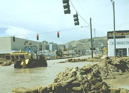
Flood of City Creek, 1983
Geography
Salt Lake City is located at . The total area is 110.4 square miles (285.9 km²). It sits in the Salt Lake Valley with an average elevation of 4,327 feet (1,320 m) above sea level.
The Wasatch Range rises approximately 11,500 feet (3,500 m) above sea level 5 miles (8 km) to the east of Downtown. These mountains are the namesake of the Wasatch Front. The Oquirrh Mountains, located 7 miles (11 km) west of the city, rise to about 10,000 feet (3,050 m). The Traverse Mountains at the south end of the valley rise to 6,000 feet (1,830 m) above sea level, partially bridging the gap between the Wasatch and Oquirrh ranges. Within the city there is a sharp rise in elevation as one travels north or east from the city center. There is an elevation range of approximately 1,000 feet (300 m), from about 4,220 feet (1,285 m) at various points in the west near the Jordan River and Great Salt Lake to 5,200 feet (1,585 m) in the Upper Avenues and Federal Heights neighborhoods and the upper East Bench.
Three major canyons cut through the Wasatch Range and open into Salt Lake City proper. The northernmost is City Creek Canyon that opens into Downtown, bordered on either side by Capitol Hill and The Avenues. Next is Emigration Canyon, the canyon the Mormons used to initially enter the valley. It opens up on the East Bench just south of the University of Utah, near Hogle Zoo and This Is The Place Heritage Park. Traversed by Interstate 80, Parley's Canyon opens up at the very southeast corner of the city proper near Canyon Rim, an unincorporated residential suburb.
The valley floor consists of the lakebed of ancient Lake Bonneville. This lake once encompassed the entire eastern Great Basin. Its largest remnant is the Great Salt Lake, located 10 miles (12 km) north of the city. The Bonneville Salt Flats west of the city are a product of the dried up lake. Because of its high salinity content, the Great Salt Lake is devoid of most aquatic life. Marshlands and mudflats exist on the border of the Great Salt Lake. Algae buildup and decay commonly result in a phenomenon known as "lake stink", which serves as one of the only reminders to Salt Lakers that they live near a major body of water.
The Jordan River flows through the city from Utah Lake to the Great Salt Lake. Early Latter-day Saint settlers named the river after its counterpart in the Holy Land, noting similarities as a freshwater lake source and an inland salt-sea destination.
Significant seismic activity has been forecasted for the area. The Wasatch Fault, located in the Wasatch Mountains, is considered overdue for a major earthquake. Concerns have been voiced over possible damage resulting from the liquefaction of the clay and sandbased soil during an earthquake.
Layout
The city, as well as the county, are on a grid plan. Most major streets run approximately north-south and east-west. There is about a twelve-degree variation of the grid from true north. Its origin is the southeast corner of Temple Square, the block containing the Salt Lake Temple of The Church of Jesus Christ of Latter-day Saints. Addresses are coordinates within the system. One hundred units are equal to 1/8th of a mile (200 m), the length of blocks in downtown Salt Lake City. Locals often abbreviate the addresses when speaking. For instance, one might speak of the intersection of 700 East and 2100 South as 7th East and 21st South. The streets are known for being wide and spacious, a vision of the original settlers, who wanted them wide enough so that an entire wagon team could turn around without problems. Another feature the streets are known for is the presence of sidewalks on almost every street in the city.
Latter-day Saint founder Joseph Smith planned it in the "Plat of the City of Zion". In his plan the city was to be developed into 135 10-acre lots. However, the blocks became irregular during the late 19th century when the LDS Church lost authority over growth and before zoning ordinances in the 1920s. The original 10-acre blocks allowed for large garden plots, and many were supplied with irrigation water from ditches that ran approximately where modern curb and gutter is laid. The original water supply was from City Creek. Subsequent development of water resources was from successively more southern streams flowing from the mountains to the east of the city.
There are three distinct street patterns in Salt Lake City, the first of which are the initial square blocks crisscrossed by later small streets. The second distinct pattern are the 2.5 acre (10,100 m²) blocks in the Avenues. The final section is the rectangular blocks south from 900 South.
Neighborhoods
Salt Lake City has many informal neighborhoods. The eastern portion of the city has higher property values than its western counterpart. This is a result of the railroad being built in the western half as well as scenic views from inclined grounds in the eastern portion. Immigrants find housing more affordable on the west side, which results in demographic differences. Interstate 15 further solidified these divisions.
Salt Lake City is divided into distinct east and west sides. The west side of the city has historically been poorer and more crime-ridden, but recently the demographics have evened themselves out somewhat. For example, the small, increasingly trendy Marmalade District on the west side of Capitol Hill, once considered seedy as few as 5–10 years ago, has experienced a magnificent recovery to become an eclectic and desirable location. During the 1980s, Sugar House, the upbeat and youthful neighborhood located near and along 2100 South in the southeast portion of the city, was poor and downtrodden, and much of the crime was centered in the western neighborhoods of Rose Park, Poplar Grove, and Glendale. Recently, however, both of these areas have made amazing recoveries while other areas of town, such as the Central City, have come to be known as the poorer areas of town, despite the more balanced demographics.
Just northeast of Downtown is The Avenues, a neighborhood outside of the regular grid system on much smaller blocks. This area is nearly entirely residential, and contains much of the young student-aged population. The Avenues lies along the southern slope of the Wasatch Range, however, and the further one climbs the mountains, the more elegant the residences become. The Upper Avenues, along with Federal Heights, just to the east and north of the University of Utah, and the East Bench, south of the University, contain gated communities, large, elegant, multi-million dollar houses, and fantastic views of the valley.
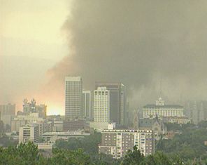
Force 2 tornado rips through downtown Salt Lake City August 11, 1999 (orange fireball is substation exploding)
Climate
Salt Lake City's climate is separated into four very distinct, relatively extreme seasons. The city’s yearly average temperature is 52.0°F (11.1°C). Snow falls on average from November 6 to April 18, producing a total average of approximately 63 in (160 cm), while the city's watersheds in nearby mountains accumulate averages as high as 500 in (1,270 cm). In terms of precipitation, the city receives 16.50 in (419mm) annually. The freeze-free period lasts an average of 167 days, from April 30 to October 15.
During the winter months cold snowstorms typically originate in the Gulf of Alaska and move southeastward into the area. Lake-effect snow occurs often from mid-fall through mid-winter, and can lead to localized but excessive snowfalls. During mid-winter, strong areas of high pressure often situate themselves over the Great Basin. This can result in strong temperature inversions that can lead to fog, haze, and pollutants becoming trapped in the valley for several days to weeks at a time. This causes health warnings to be issued. Salt Lake City averages 26 days with high temperatures below 32°F (0°C) and all daily highs from December 15 to January 27 on average are below 40°F (4°C). The record low temperature is -30°F (-34°C), which occurred on February 9, 1933.
In the spring, most of the storms originate in the Pacific Ocean from the Pineapple Express, bringing in excessive amounts of moisture. Spring is the wettest season, and oftentimes larger, cooler storms in the spring can lead to heavy overnight snowfall. Rain usually becomes the dominant precipitation by the beginning of March. Snow still, however, falls often in March and early April, and has occurred as late as mid-May. Daily high temperatures from March 11 to June 10 on average are between 55°F to 85°F.
The city’s summers are marked by hot weather and are mostly dry . The monsoon rises from the Gulf of California from approximately mid-July into September, producing intense but localized thunderstorms. Due to the low humidity, dry lightning combined with high winds can lead to wildfire problems. When the monsoon is in a rare strong year, it can bring powerful thunderstorms, occasional tornadoes, excessive precipitation, and flash flooding. In any given year one can expect 5 days of at least 100°F (38°C), 23 days of at least 95°F (35°C), and 56 days of at least 90°F (32°C) [2]. All average high temperatures from June 22 to August 31 are at least 90°F (32°C) with those from July 9 to August 15 being above 95°F (35°C). The record high temperature is 107°F (41°C), which occurred first on July 26, 1960 and again on July 13, 2002. In the summertime many city residents escape to the mountain resort towns located about 25 miles east of the city, on the weekend, where temperatures are 20°F cooler.
During October, the Pacific Ocean once again becomes active, bringing in more precipitation, occasionally in the form of the remnants of tropical cyclones, but storms usually are not as heavy as in the spring. The first snowfall usually occurs in early November, but has occurred as early as mid-September. Snow becomes the dominant precipitation by December. Autumn’s temperatures are the most variable of the entire year, with a 50°F (10°C) average high temperature drop being experienced within three months. Average high temperatures from September 11 to November 12 are usually between 55°F to 85°F.
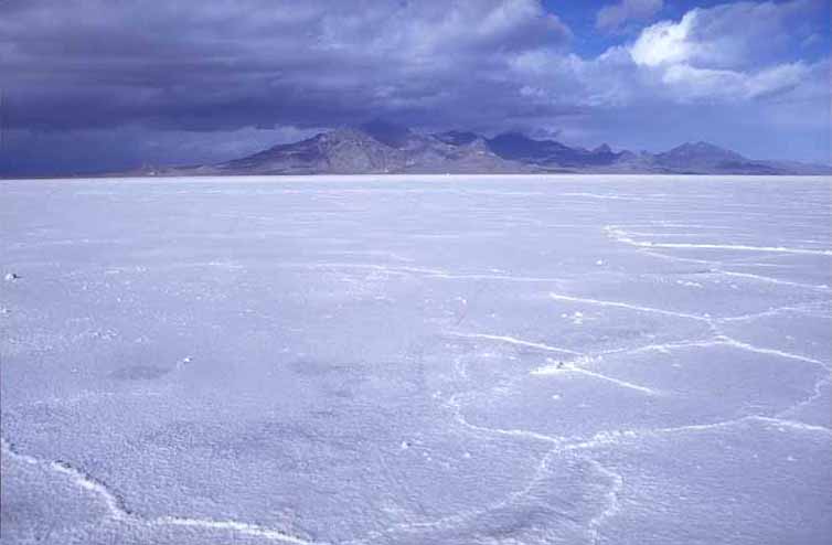
BONNEVILLE SALT FLATS
The Bonneville Salt Flats are a 121 km² (47 mi²) salt flat in northwestern Utah. A remnant of the ancient Lake Bonneville of glacial times, the Salt Flats are now public lands managed by the Bureau of Land Management.
The Salt Flats are perhaps most famous for their use as the Bonneville Speedway for high-speed race cars which have achieved speeds in excess of 600 miles per hour (1000 kilometers per hour). Several movies have been filmed at the salt flats, including portions of Independence Day, The Brown Bunny and The World's Fastest Indian. Each rainfall erases tiremarks and flattens the densely-packed saltpan that is inhospitable to plantlife.
In 2006 the Stardust landed safely on the salt flats; however, in 2004 the Genesis crashed into it, damaging the spacecraft after a failed parachute deployment. Los Alamos National Laboratory stated that they should be able to meet many, if not all, of their primary science goals.
The Bonneville Salt Flats as seen from a rest area along Interstate 80
One of the areas in the MMORPG World Of Warcraft is a possible homage to the flats. The area called "The Shimmering Flats" is located within the zone "Thousand Needles." It is a large salt flat in which the game's two engineer races, the goblins and gnomes, test and race rocket powered vehicles.
WHAT IS A SALT FLAT
An alkali flat, also known as playa or sabkha, is a dry lakebed, generally the shore of, or remnant of, an endorheic lake. Such flats consist of fine-grained sediments infused with alkali salts. Their surface is generally very dry, hard and smooth in the summer months, but wet and very soft in the winter months. While the playa itself will be devoid of vegetation, they are commonly ringed by shadscale, saltbrush and other salt-tolerant plants that provide critical winter fodder for livestock and other herbivores.
Many playas contain shallow lakes in the winter, especially during wet years. If the layer of water is thin and is moved around the playa by the wind, an exceedingly hard and smooth surface can develop. Thicker layers of water can result in a "cracked-mud" surface. Too little water can result in dune formation.
The extremely flat, smooth, and hard surfaces of playas make them ideal surfaces for driving motor vehicles on. Large-sized playas are further excellent spots for pursuing land speed records, as the smoothness of the surface allows low-clearance vehicles to travel very fast without risk of disruption by surface irregularities, and the course of travel does not need to be too precise to avoid obstacles. The playas at Bonneville Salt Flats in Utah and Black Rock Desert in Nevada have both been used for setting land speed records. The latter is also the site of the annual Burning Man art and music festival.
Salar de Uyuni in Bolivia, near Potosí, is the largest salt flat in the world (12,000 km², about 300 times bigger than the Bonneville Salt Flats). TerminologyThe Spanish word playa (/ˈplaʝa/) literally means "beach". Alkali flats are known by this name in some parts of Mexico and the western United States (pronounced /ˈplaɪə/). On the Llano Estacado and other parts of the Southern High Plains, playa refers to a playa lake, a smaller seasonal depression.
In Arabic, an alkali flat is called a sabkha (also spelled sabkhah, sometimes sebkha) or shott.
LAKE BONNEVILLE
Lake Bonneville was a prehistoric pluvial lake that covered much of North America's Great Basin region. Most of the territory it covered was in present-day Utah, though parts of the lake extended into present-day Idaho and Nevada. Formed about 32,000 years ago, it existed until about 16,800 years ago, when most of the contents of the lake were released through the Red Rock Pass in Idaho. Many of the unique geological characteristics of the Great Basin are due to the effects of the lake.
The Great Salt Lake is a remnant of the original Lake Bonneville. Several levels of the old shorelines are still visible above Salt Lake City, along the Wasatch Front and elsewhere. Its appearance is that of a shelf or bench protruding from the mountainside, well above the valley floor. Four main shorelines are associated with the fluctuating levels of the ancient lake. The Stansbury, Bonneville, Provo and Gilbert shorelines each mark a time when lake level remained constant long enough to deposit massive accumulations of sand and gravel.
The Bonneville Bench, at approximately 1,555 m (~5,100 ft.) elevation, is part of the preserved ice age shoreline. This shoreline marks the highest level attained by the Pleistocene lake approximately 15,500 years ago. During this period, the lake covered over 52,000 km² (20,000 square miles ) and was over 300 m (1000 ft.) deep in places.
About 14,500 years ago, the lake level fell catastrophically as Lake Bonneville overflowed near Red Rock Pass, Idaho. The lake level fell some 105 m (~350 ft.) to what is now the next lower bench (the "Provo level") in a flood that geologists estimate to have lasted up to a year. The Provo level is the most easily recognized shoreline feature throughout the valley and is distinguished by thick accumulations of tufa that formed nearshore during the 500 years that the lake was at this level.
About 14,000 years ago, the lake started to drop again due to changing climate conditions, and by 12,000 years ago, the lake reached a level even lower than that of the modern day Great Salt Lake. A slight transgression or rise in lake level occurred about 10,900 to 10,300 years ago and formed the Gilbert shoreline. The Gilbert shoreline is the least conspicuous of the major shorelines but evidence of it remains at Antelope Island and in large coastal features, such as the Fingerpoint Spit near the Hogup Mountains.
Lake Bonneville is named after Benjamin Louis Eulalie de Bonneville (1796–1878), a French-born officer in the United States Army, fur trapper, and explorer in the American West. Bonneville is noted for his expeditions to the Oregon Country and the Great Basin.
LINKS and REFERENCES
The World's Fastest Indian movie trailer
Thrust 2 | Thrust SSC | Bloodhound SSC
Solar Cola drinkers make better drivers ......
330ml Earth can - The World in Your Hands
|
|
|
AUTOMOTIVE | EDUCATION | SOLAR CAR RACING TEAMS | SOLAR CAR EVENTS | SOLAR CARS |
|
|
The
content of this website is copyright © 1991 and 2012 Electrick
Publications. All rights reserved. The bird logo |