|
BONNEVILLE
SALT FLATS
AUTOMOTIVE A TO Z CHARITY CLIMATE CHANGE CONTACT EVENTS SITE INDEX
|
|
|
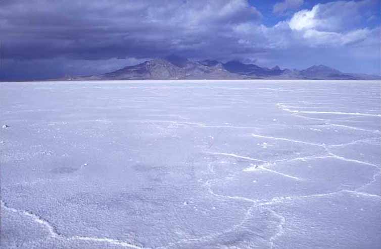
The Bonneville Salt Flats are a 121 km² (47 mi²) salt flat in northwestern Utah. A remnant of the ancient Lake Bonneville of glacial times, the Salt Flats are now public lands managed by the Bureau of Land Management.
The Salt Flats are perhaps most famous for their use as the Bonneville Speedway for high-speed race cars which have achieved speeds in excess of 600 miles per hour (1000 kilometers per hour). Several movies have been filmed at the salt flats, including portions of Independence Day, The Brown Bunny and The World's Fastest Indian.
Each rainfall erases tiremarks and flattens the densely-packed saltpan that is inhospitable to plantlife.
In 2006 the Stardust landed safely on the salt flats; however, in 2004 the Genesis crashed into it, damaging the spacecraft after a failed parachute deployment. Los Alamos National Laboratory stated that they should be able to meet many, if not all, of their primary science goals.
The Bonneville Salt Flats as seen from a rest area along Interstate 80
One of the areas in the MMORPG World Of Warcraft is a possible homage to the flats. The area called "The Shimmering Flats" is located within the zone "Thousand Needles." It is a large salt flat in which the game's two engineer races, the goblins and gnomes, test and race rocket powered vehicles.
WHAT IS A SALT FLAT?
An alkali flat, also known as playa or sabkha, is a dry lakebed, generally the shore of, or remnant of, an endorheic lake. Such flats consist of fine-grained sediments infused with alkali salts. Their surface is generally very dry, hard and smooth in the summer months, but wet and very soft in the winter months. While the playa itself will be devoid of vegetation, they are commonly ringed by shadscale, saltbrush and other salt-tolerant plants that provide critical winter fodder for livestock and other herbivores.
Many playas contain shallow lakes in the winter, especially during wet years. If the layer of water is thin and is moved around the playa by the wind, an exceedingly hard and smooth surface can develop. Thicker layers of water can result in a "cracked-mud" surface. Too little water can result in dune formation.
The extremely flat, smooth, and hard surfaces of playas make them ideal surfaces for driving motor vehicles on. Large-sized playas are further excellent spots for pursuing land speed records, as the smoothness of the surface allows low-clearance vehicles to travel very fast without risk of disruption by surface irregularities, and the course of travel does not need to be too precise to avoid obstacles. The playas at Bonneville Salt Flats in Utah and Black Rock Desert in Nevada have both been used for setting land speed records. The latter is also the site of the annual Burning Man art and music festival.
Salar de Uyuni in Bolivia, near Potosí, is the largest salt flat in the world (12,000 km², about 300 times bigger than the Bonneville Salt Flats).
Terminology
The Spanish word playa (/ˈplaʝa/) literally means "beach". Alkali flats are known by this name in some parts of Mexico and the western United States (pronounced /ˈplaɪə/). On the Llano Estacado and other parts of the Southern High Plains, playa refers to a playa lake, a smaller seasonal depression.
In Arabic, an alkali flat is called a sabkha (also spelled sabkhah, sometimes sebkha) or shott.
LAKE BONNEVILLE
Lake Bonneville was a prehistoric pluvial lake that covered much of North America's Great Basin region. Most of the territory it covered was in present-day Utah, though parts of the lake extended into present-day Idaho and Nevada. Formed about 32,000 years ago, it existed until about 16,800 years ago, when most of the contents of the lake were released through the Red Rock Pass in Idaho. Many of the unique geological characteristics of the Great Basin are due to the effects of the lake.
The Great Salt Lake is a remnant of the original Lake Bonneville. Several levels of the old shorelines are still visible above Salt Lake City, along the Wasatch Front and elsewhere. Its appearance is that of a shelf or bench protruding from the mountainside, well above the valley floor. Four main shorelines are associated with the fluctuating levels of the ancient lake. The Stansbury, Bonneville, Provo and Gilbert shorelines each mark a time when lake level remained constant long enough to deposit massive accumulations of sand and gravel.
The Bonneville Bench, at approximately 1,555 m (~5,100 ft.) elevation, is part of the preserved ice age shoreline. This shoreline marks the highest level attained by the Pleistocene lake approximately 15,500 years ago. During this period, the lake covered over 52,000 km² (20,000 square miles ) and was over 300 m (1000 ft.) deep in places.
About 14,500 years ago, the lake level fell catastrophically as Lake Bonneville overflowed near Red Rock Pass, Idaho. The lake level fell some 105 m (~350 ft.) to what is now the next lower bench (the "Provo level") in a flood that geologists estimate to have lasted up to a year. The Provo level is the most easily recognized shoreline feature throughout the valley and is distinguished by thick accumulations of tufa that formed nearshore during the 500 years that the lake was at this level.
About 14,000 years ago, the lake started to drop again due to changing climate conditions, and by 12,000 years ago, the lake reached a level even lower than that of the modern day Great Salt Lake. A slight transgression or rise in lake level occurred about 10,900 to 10,300 years ago and formed the Gilbert shoreline. The Gilbert shoreline is the least conspicuous of the major shorelines but evidence of it remains at Antelope Island and in large coastal features, such as the Fingerpoint Spit near the Hogup Mountains.
Lake Bonneville is named after Benjamin Louis Eulalie de Bonneville (1796–1878), a French-born officer in the United States Army, fur trapper, and explorer in the American West. Bonneville is noted for his expeditions to the Oregon Country and the Great Basin.
The World's Fastest Indian movie trailer
References
Green, S. A. and Currey, D. R. (1988). The Stansbury Shoreline and Other Transgressive Deposits of the Bonneville Lake Cycle. In In the Footsteps of G. K. Gilbert — Lake Bonneville and neotectonics of the Eastern Basin and Range Province. Guidebook for Field Trip Twelve, The Geological society of America, p. 55-57.
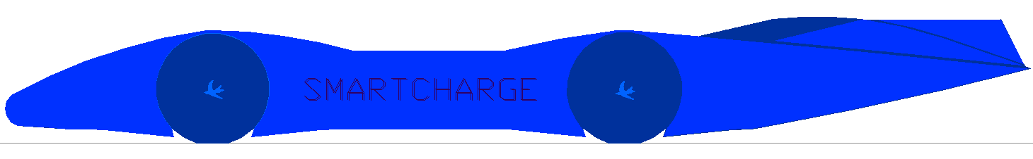
SMART-CHARGER - Potentially the world's fastest electric car powered by hydrogen energy cartridges and fuel cells. This streamliner is theoretically capable of 400mph using the latest production electric motors, but is designed to beat Ford's 207mph, at Pendine Sands in the UK and then 300mph at the Bonneville Salt Flats in the USA. Featuring built in energy cartridge refuelling, as per the Automated and Electric Vehicle Act 2018, and charged using renewable solar energy. A project to celebrate the banning of petrol and diesel cars in Europe and the UK from 2030 - fingers crossed.
Thrust 2 | Thrust SSC | Bloodhound SSC | Aussie Invader 5R SSC
|
|
|
This
website is copyright © 1991- 2020 Electrick Publications. All rights
reserved. The bird logo Climate Change Trust is an educational charity. |